Equatorial Guinea Volcanoes
-
Santa Isabel
-

San Carlos
-
San Carlos
-
San Joaquin
-
San Joaquin
-
Santa Isabel
Equatorial Guinea has 3 Holocene volcanoes. Note that as a scientific organization we provide these listings for informational purposes only, with no international legal or policy implications. Volcanoes will be included on this list if they are within the boundaries of a country, on a shared boundary or area, in a remote territory, or within a maritime Exclusive Economic Zone. Bolded volcanoes have erupted within the past 20 years. Suggestions and data updates are always welcome ().
| Volcano Name | Location | Last Eruption | Primary Volcano Type |
|---|---|---|---|
| San Carlos | Bioko Island (Equatorial Guinea) | Unknown - Evidence Credible | Shield |
| San Joaquin | Bioko Island (Equatorial Guinea) | Unknown - Evidence Credible | Shield |
| Santa Isabel | Bioko Island (Equatorial Guinea) | 1923 CE | Shield |
Chronological listing of known Holocene eruptions (confirmed or uncertain) from volcanoes in Equatorial Guinea. Bolded eruptions indicate continuing activity.
| Volcano Name | Start Date | Stop Date | Certainty | VEI | Evidence |
|---|---|---|---|---|---|
| Santa Isabel | 1923 | Unknown | Confirmed | Observations: Reported | |
| Santa Isabel | 1903 | Unknown | Confirmed | Observations: Reported | |
| Santa Isabel | 1898 (?) | Unknown | Confirmed | Observations: Reported |
Equatorial Guinea has 0 Pleistocene volcanoes. Note that as a scientific organization we provide these listings for informational purposes only, with no international legal or policy implications. Volcanoes will be included on this list if they are within the boundaries of a country, on a shared boundary or area, in a remote territory, or within a maritime Exclusive Economic Zone. Suggestions and data updates are always welcome ().
There are 6 photos available for volcanoes in Equatorial Guinea.
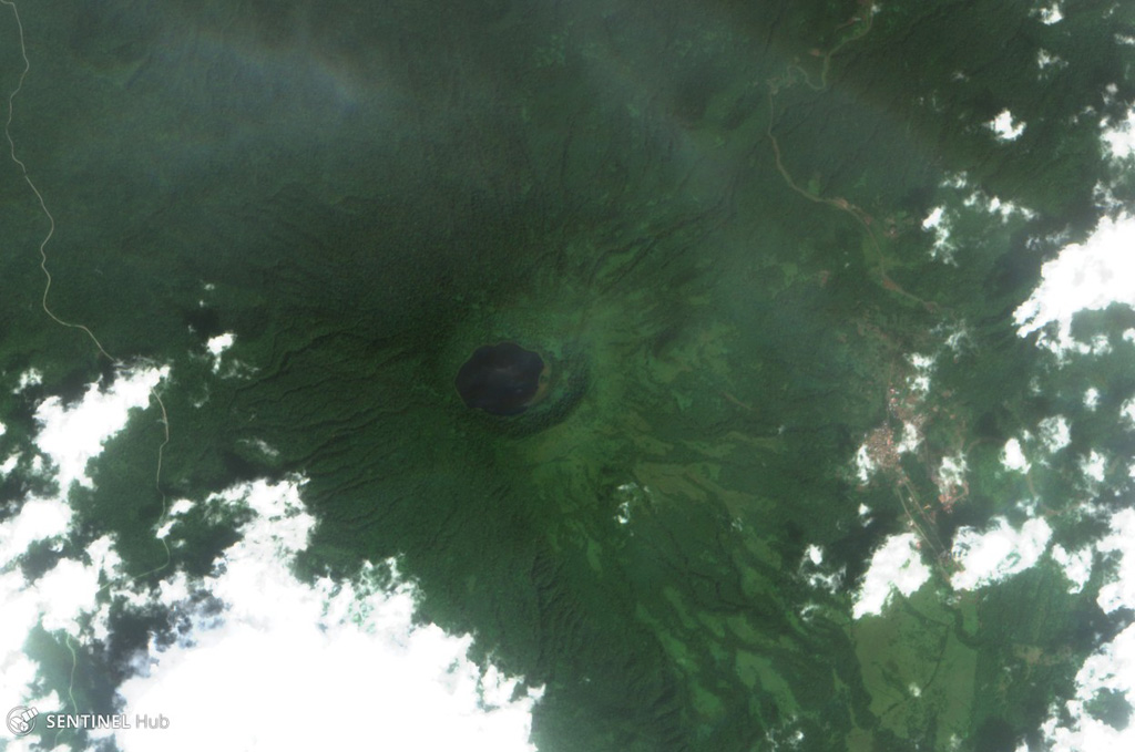
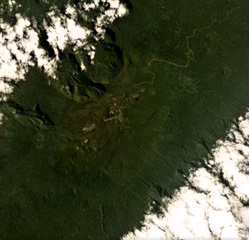
 Lago Biao fills the San Joaquin (also called Pico Biao) caldera, seen in this 26 December 2017 Sentinel-2 satellite image (N at the top). The caldera is approximately 1.5 km wide and is covered in dense forest. It is W of San Carlos, in the SE of Bioko Island in Equatorial Guinea.
Satellite image courtesy of Copernicus Sentinel Data, 2017.
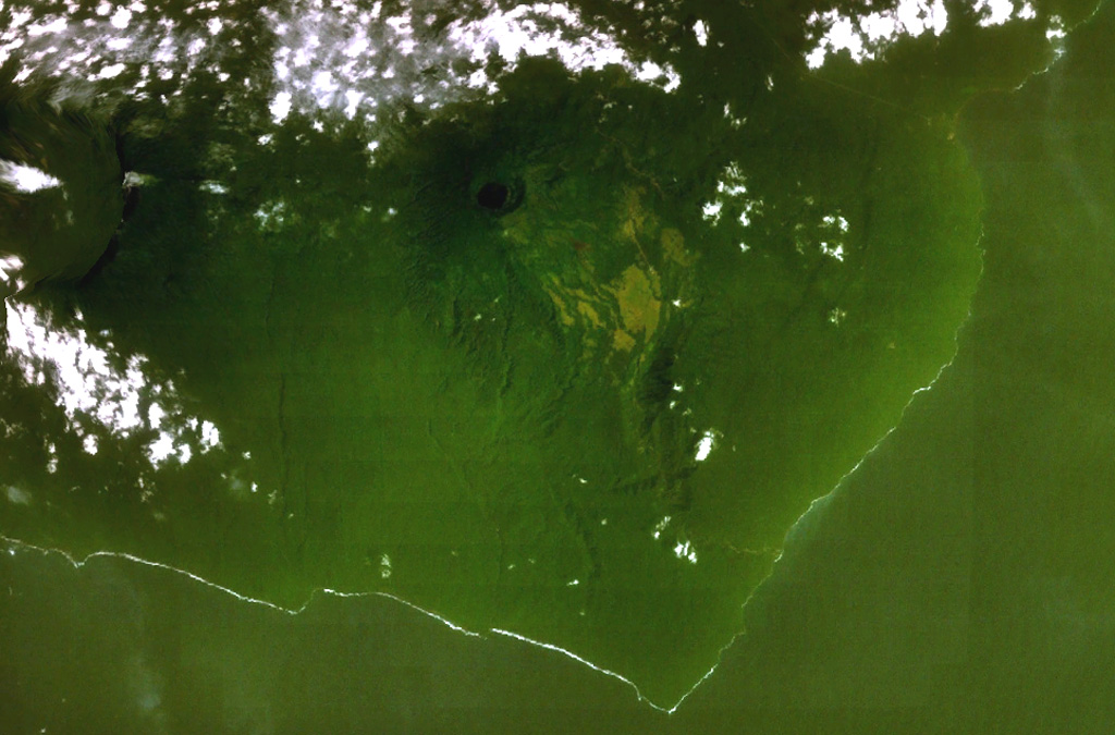
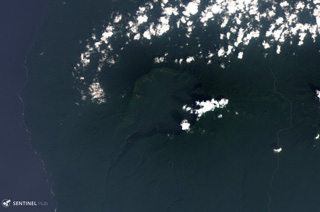
 A dark-colored lake partially fills a small caldera (top-center) occupying the summit of San Joaquin volcano in this NASA Landsat view with north to the top. This basaltic shield volcano, also known as Pico Biao, lies on the SE side of Bioko (Fernando Poo) Island in the Gulf of Guinea. Part of the broad summit caldera of neighboring San Carlos volcano can be seen at the left.
NASA Landsat 7 image (worldwind.arc.nasa.gov)
 A broad caldera, partially surrounded by clouds left of center, cuts the summit of San Carlos volcano. This a basaltic shield volcano forms the toe on the SW side of boot-shaped Bioko (Fernando Poo) Island. This NASA Landsat view (with north to the top) also shows neighboring San Joaquin volcano, with its smaller lake-filled caldera, at the right.
NASA Landsat 7 image (worldwind.arc.nasa.gov)
 Santa Isabel volcano occupies the northern end of Bioko (Fernando Poo) Island in this NASA Landsat view with north to the upper left. A large escarpment cuts the northern side of the 3,007-m-high volcano, whose summit is cut by regional NE-SW-trending faults. Numerous scoria cones are present, many of which lie along the same tectonic trend. Santa Isabel is the only Bioko Island volcano with reported historical eruptions, although they are poorly documented. The brown area along the northern coast is the capital city of Malabo.
NASA Landsat image, 1999 (courtesy of Hawaii Synergy Project, Univ. of Hawaii Institute of Geophysics & Planetology).
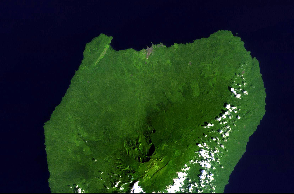
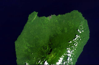
 Santa Isabel (also called Pico Basile) is near the northern end of Bioko Island in Equatorial Guinea, seen here in this May 2019 Planet Labs satellite image mosaic (N at the top). Several eruptions occurred on the SE flank between 1989 and 1923. Several craters are visible across the summit area through the center of this image.
Satellite image courtesy of Planet Labs Inc., 2019 (https://www.planet.com/).
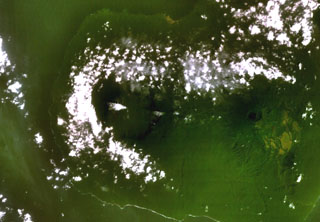
 San Carlos is located in the south of Bioko Island in Equatorial Guinea and has a roughly 5.5-km-wide caldera, seen here in a 5 January 2019 Sentinel-2 satellite image (N at the top). A valley through the SW flank opens the crater towards the Atlantic Ocean.
Satellite image courtesy of Copernicus Sentinel Data, 2019.
This is a compilation of Equatorial Guinea volcano information sources, such as official monitoring or other government agencies.
| Volcanic Ash Advisory Center | |
|---|---|
| Washington Volcanic Ash Advisory Center (VAAC) | |
| - Washington VAAC Archive | |
| - Washington VAAC Notices | |